Death at Midnight: The St. Francis Dam Disaster

11:58 p.m., March 12, 1928 –– Residents in the settlements of the San Francisquito Valley, some 45 miles north of Los Angeles, were shaken awake. The cause was not an earthquake, but the epic fail of the massive, newly-constructed dam looming over the valley.

When the St. Francis dam gave way, it went quickly and catastrophically. Dozens were killed in the first five minutes, inundated by a wall of water 140 feet high. As 12 billion gallons of water thundered out of the valley and on to the ocean near Oxnard, the torrent swept at least 400, and perhaps as many as 600, persons to their deaths. Following the disaster bodies were found everywhere from right up at the dam site (one) to the border of Mexico. A hundred or more of the missing were never found.

In addition to the human toll, the floodwaters devastated the towns of Castaic Junction, Piru, Fillmore, Santa Paula, and Saticoy in the Santa Clara Valley. Roads, bridges, and power lines were wiped out. Livestock died in the fields.

Eighty-nine years later it is worth recalling the devastation caused by miscalculating the power of water. Photos from the Los Angeles Public Library collections show the dramatic aftermath of the worst man-made disaster in California’s history.

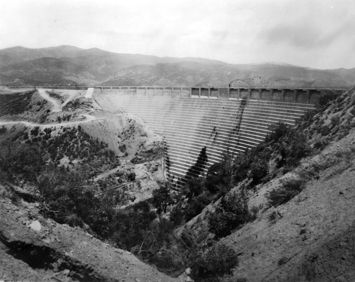
The St. Francis Dam was built to store water from the Owens Valley Aqueduct System.  Security Pacific National Bank Collection, Image #00009818

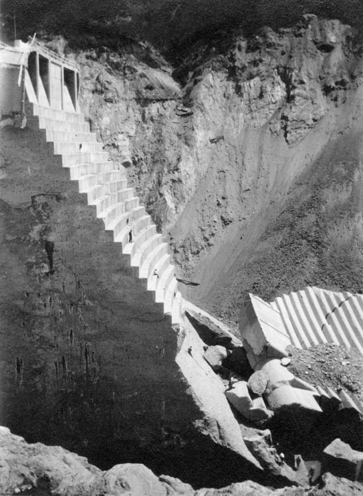
The state-of-the-art St. Francis Dam had been open two years and its reservoir had filled to capacity for the first time when tragedy struck. In the photo above, the reservoir lake is still several feet below the lip of the dam.


Shiny generators at Power Plant #2 in the vicinity of the St. Francis Dam stand ready to turn water into electric power. Ironically, the power plant was destroyed by the very waters it sought to harness. Unlike the dam, the plant was quickly rebuilt. Security Pacific National Bank Collection, Image #00009831, 1928. 

This photo, taken shortly before the collapse, shows the stair-step design on the face of the dam. Some “seeps” of water were considered to be no big deal. Security Pacific National Bank Collection, Image #00009832.


Eerie Monuments

Security Pacific National Bank Collection, Image #00009834 . Photo Credit, “Underwood & Underwood.”

The only major chunk of dam to remain standing following the break was dubbed “the Tombstone” by a reporter. The accidental landmark and surrounding ruins became a mecca for tourists shortly after the cataclysm. After the death from falling of one such thrill seeker, the Tombstone and other monoliths were dynamited.


Close inspection of this photograph reveals several people on the stair steps of the Tombstone. Security Pacific National Bank Collection, Image #00009821.


Security Pacific National Bank Collection, Image #00075797.


Enormous chunks of the dam were found thousands of feet downstream, turning the valley floor into a bizarre sculpture garden. A gentleman standing in front of this “concrete iceberg” provides scale. Security Pacific National Bank, Image # 00075796.
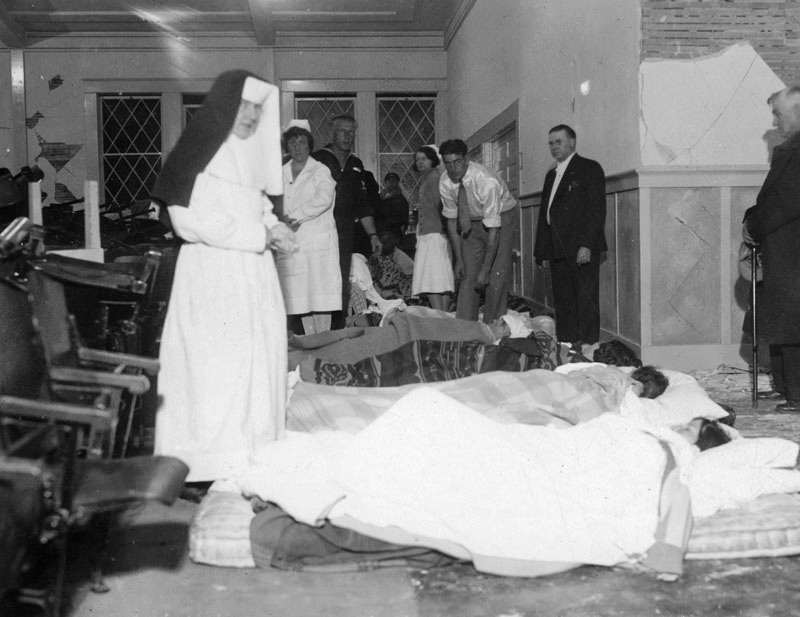
The Frightful Flood

The horror of the catastrophe cannot be understated. Communities around the country awoke to the shocking news:

County Farm Advisor H. A. Weinland left Tuesday for the southern part of the state upon receiving the sad news that his brother, William Weinland, and the latter’s wife and ten-year-old son had been swept to death in the frightful flood through San Francisquito canyon Monday night, caused by the breaking of St. Francis dam. Weinland received a telegram from his father, Rev. William H. Weinland of Banning, telling of the death of his relatives. Weinland’s body has been found but those of his wife and son are yet lost somewhere in the depth of silt which the rushing waters from the huge reservoir above the dam left behind. The Sonoma County man’s brother was employed at one of the power stations near the dam and lived in a cottage in the valley directly below the reservoir. It is believed the flood caught the little family as they slept like it did scores of other unfortunate families. (Healdsburg Tribune, March 15, 1928)

A few fortunate souls survived the onslaught. The Associated Press paraphrased the words of an 80-year rancher plucked from the raging waters by one of his sons:

“When the water hit it, the house crumpled as though it were built of cards. I could not see a thing in the darkness and found myself clinging to what turned out to be a part of the roof of our home. Down, down with the current we went. I held on desperately. I kept saying to myself every second was my last. Then … somebody grabbed my arm in the darkness. ‘Is it you, dad?'” (Seattle Daily Times, March 13, 1928)

The report goes on to inform readers that the man’s other two sons lay in a temporary morgue nearby.


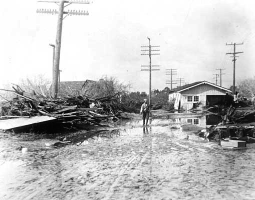
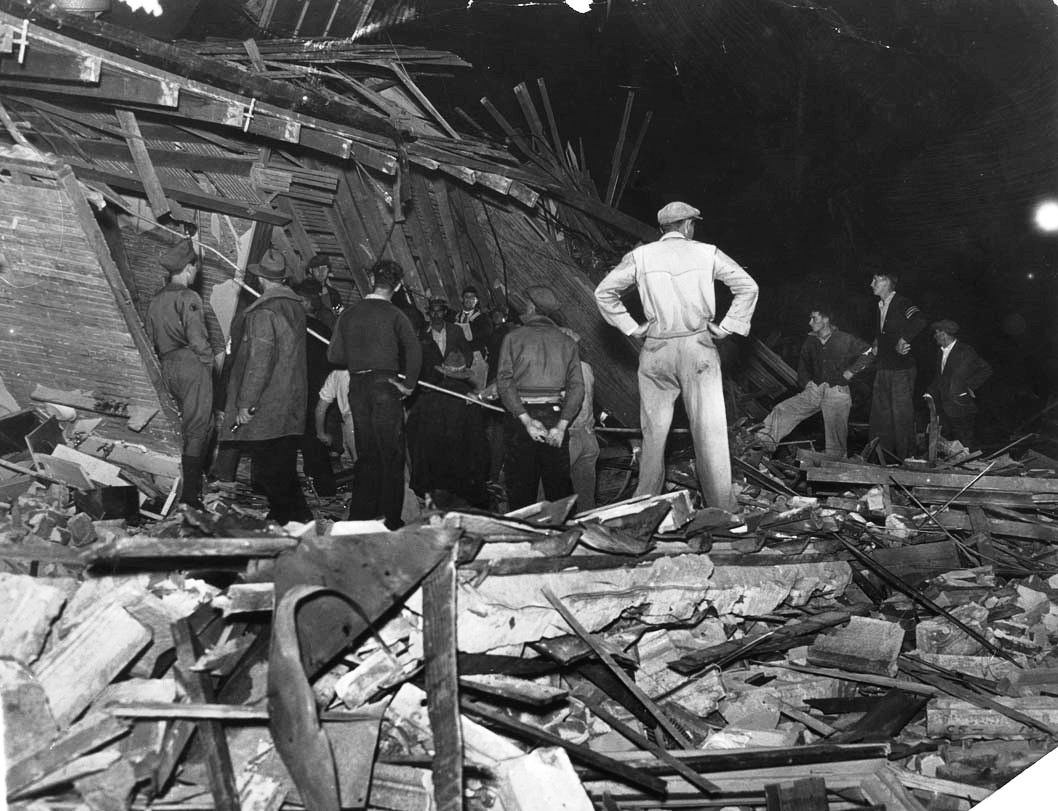
The clean up begins. Security Pacific National Bank Collection, Image #00017361, dated March 16, four days after the disaster. Photo credit “Underwood & Underwood.”


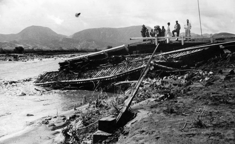
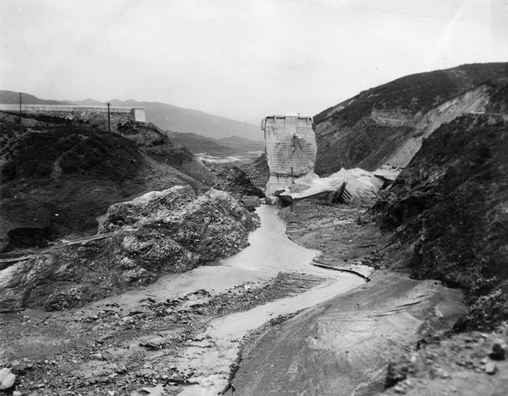
People survey the devastation along the Santa Clara River, the path the dam waters took to the sea. A railroad bridge lies in ruins. Security Pacific National Bank Collection #00070192, 1928. 


Schist happens


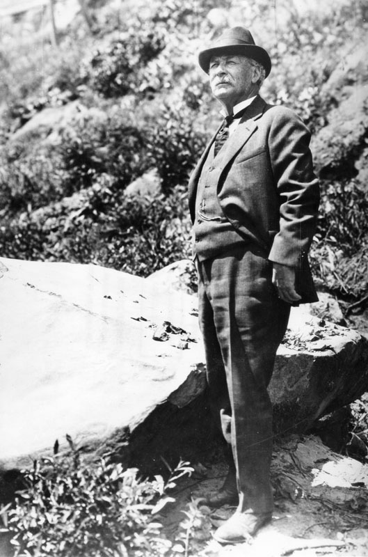
William Mulholland (1855-1935) in an undated photo. Security Pacific National Bank Collection, Image #00043872.

The man behind the dam: William Mulholland  was Chief Engineer of the Los Angeles Bureau of Water Works and Supply (now the Department of Water and Power). His towering reputation earned in the “water wars” of Southern California was largely wiped out, along with his career, after the St. Francis Dam disaster. Mulholland had personally inspected the dam only 12 hours before the disaster at the urging of the dam’s caretaker, and had pronounced it sound.

Any number of inquiries have attempted to find the cause of the disaster. While Mulholland initially clung to the theory of an earthquake, this was ruled out early on. Most experts point to geologic factors, especially the unstable hillsides that abutted the dam made up of landslide-prone schist (a type of metamorphic rock that splits easily) on one side and softened conglomerate (a type of gravel-like sedimentary rock) on the other. In short, the  rock at the dam site was bad rock for a massive construction project.  There were also errors in design. Mulholland had twice raised the height of the dam during construction without allowing for the increased water pressure that would result. 


This photo from the Los Angeles Evening Herald is dated March 28, 1928, two weeks after the dam collapse; the caption reads “From districts swept by the St. Francis dam flood came more stories of heroic phone operators who stuck to their posts and saved scores of lives at risk of their own. Louise Gipe received and spread the first alarm at Santa Paula.” Image Herald Examiner Collection #00095916, Photo credit “Moss Photo.”

Even more than with the Long Beach Earthquake five years later, the St. Francis Dam disaster played havoc with communication. The disaster unfolded in the dark of night, taking power lines with it. The wave of water took five and a half hours to reach the sea, arriving just before dawn near Oxnard. For those in San Francisquito Canyon there was no early warning and no escape from the tsunami of water. Farther along the waters’ path, as the height of the wave lessened, some folks were able to escape to higher ground thanks to intrepid individuals such as telephone operator Louise Gipe who stood by her post and relayed a warning to residents of Santa Paula. Alerted by Gipe, California Highway Patrol officers went house to house to wake residents. At a work camp in the path of the deluge, the night watchman raised the alarm upon seeing the approaching wave. He is credited with saving half the sleeping workforce, at the cost of his own life.

The St. Francis Dam was never rebuilt. Lessons learned from the disaster informed the design, construction, and inspection protocols of dams throughout the country.

Disaster Response: The 1933 Long Beach Earthquake

On Friday, March 10, 1933, in the depth of the Great Depression, the Southland experienced a major earthquake, centered off of Long Beach. While named for that city, the event, and the many aftershocks, affected the entire Los Angeles basin and was felt as far south as Tijuana. Some 120 persons were killed (the exact number is disputed*): about half in Long Beach proper and the rest in communities including Compton, Cerritos, and Huntington Beach. Serious property damage occurred throughout the region, including in Los Angeles City itself.

A young seismologist named Charles F. Richter counted seven aftershocks of “marked intensity.” Richter went on to tell the United Press: “Thereafter a series of continuous quakes began. They were too frequent to be correctly tabulated. I should estimate them at from 100 to 200 up to noon Saturday.” (Quoted in Seattle Times,  “12Towns….”) Two years following the event, Richter developed his famous scale which rated the initial 1933 earthquake at 6.4.

Residents and newspapers photographers documented the devastation and the recovery efforts. In this photo essay, we will focus on immediate aid efforts and the resilience of the citizenry.


00058879

Security Pacific National Bank Collection, Image #00058879

The earthquake caused widespread devastation, collapsing many buildings, including 70 schools and public buildings such as the Lynwood Theater. Another 50 schools and many other buildings sustained serious damage. Fortunately, the quake occurred at the dinner hour, after school had recessed for the day. Had it happened earlier, the death toll would have been much higher and much younger!


00047523

Herald Examiner Collection, #00047523

Rescuers pause to listen for victims who may be trapped in the wreckage of the Stockwell Building in Compton, March 11, 1933. Compton suffered extensive destruction in its core commercial district.


00058878

Security Pacific National Bank Collection, #00058878

Medical personnel, including Catholic sisters and staff from U.S. Navy ships at San Pedro were called in to help with the wounded. With hospitals damaged, the wounded were brought to churches, parking lots, and other locations. Another photo, not shown here, shows covered bodies on mattresses behind Seaside Hospital (Herald-Examiner Collection, Image #00057404).

Many were injured or killed by falling bricks in the streets.


Making Shift

00057405

Herald Examiner Collection, Image #00057405

In the days following the quake, and with after-shocks coming thick and fast, most families in the quake zone chose to camp outdoors, either in parks or in their own yards. The Long  Beach area was dotted with small fires such as this one. The caption accompanying this photo in the Herald Examiner read: “Through the night of the March 10 earthquake, thousands of men, women and children sat up beside bonfires in vacant lots and yards as they feared to enter their homes lest there be further temblors.”


00020435

Security Pacific National Bank Collection, Image #00020435

This family in Compton has set up a makeshift camp stove in their yard. The quake took out electric power and officials shut off gas, likely preventing further disasters.

00020448

Security Pacific National Bank Collection, Image #00020448

There’s a lot going on in this photo, including several makeshift stoves with fuel at the ready. The men in charge may be running a pop-up business, catering to those without means to heat food.

00084131

Herald Examiner Collection, Image #00084131

The Community Pulls Together

It takes a community to recover from a disaster. The Herald-Examiner’s caption for the above photo, dated March 14, 1933, read “All Southern California opened its heart and sent food and medicine to the homeless and injured. Volunteer workers are shown carrying boxes of supplies prepared by sympathetic Angelenos.”

00057407

Photo by “Crory,” Herald Examiner Collection, Image #00057407

Residents line up for food and other assistance at Lincoln Park, close by Long Beach City Hall, March 12, 1933, two days after the quake. The Red Cross and Salvation Army set up first aid tents and feeding stations. Long Beach city officials trucked in fresh water. Some restaurants offered what they had on hand at no charge.

00047510

Herald-Examiner Collection, Image #00047510

Commerce must go on. With most stores and businesses at least temporarily uninhabitable, merchants took to the streets to sell their wares. In Compton they were allowed to set up within an undamaged structure — the Oil Exposition building — where they arranged themselves in the same order as their main street shops.

00057399

Frank Bentley, photographer, Herald Examiner Collection, Image #00057399

With power and telephone poles down throughout the region, communication with the outside world was difficult. Ham radio stations were credited with offering the only reliable communication for the first week following the cataclysm. According to some, the first word of the disaster came from a boy’s ham radio station ten minutes after the initial quake. Here, amateur radio enthusiasts, assisted by the Boy Scouts, offer the services of their short-wave radio station. Survivors were able to send messages to anxious loved ones via wireless technology. Press services also availed themselves of on-the-ground reports transmitted via short-wave. With the region under virtual martial law for a number of days, reporters had a difficult time gaining access to the quake zone.


00034804

Herald Examiner Collection, Image #00034804

Military personnel called out to assist with the recovery efforts take advantage of coffee and donuts provided by the Salvation Army in Compton. The soldier at right is reading an “EXTRA” addition of the paper with the headline “120 Killed in Quake.” Curiously, the number is fairly accurate.

If not for the newspaper, one might be led to believe this was a photo from World War I. The sailors, referred to in the press as “bluejackets,” carried bayonets while patrolling disaster-stricken streets.

Some of the men pictured appear to be members of the American Legion. The Disaster Relief Committee of the American Legion stepped up to the challenge , distributing supplies and patrolling streets. An interesting press item, copied from a March 16 letter of the American Legion post in Long Beach to his fellow commanders, offers a glimpse at the state of things five days following the quake:

Dear Comrade Commander:

Pay no attention to radio broadcasts, either commercial or amateur, requests for food until broadcast by Colonel A. C. Wyman or Ole Olson. Clothing of all kinds needed, especially men’s shoes. Send to Compton or Long Beach American Legion. Fraternally yours, L.F. Olson, acting disaster relief chairman, The American Legion, Department of California (Coronado Eagle and Journal, March 21, 1933)


00047508

American Legion relief station adjacent to the ruins of Compton City Hall, March 13, 1933. Herald Examiner Collection, Image #00047508


00084132

Herald Examiner Collection, Image #00084132

Four days after the quake, with most folks still camped out in parks and on golf courses, boredom became an issue. These young women attempt to alleviate the problem with the aid of the old upright at Long Beach’s Bixby Park.

Finding Fault?

Thanks to its location within a major metropolitan area, and with access to trained emergency response and federal assistance, recovery from the Long  Beach earthquake was relatively rapid. Within two weeks most families were able to return to their homes. Lessons were learned. Many who had believed Southern California immune from big earthquakes found out otherwise. The need for construction standards and the risks of building on landfill became apparent. A month following the disaster, the state legislature passed the Field Act, mandating state-approved standards for school-building.

At this writing, fall of 2016, a new geological report suggests that the 1933 earthquake and others of the same era and location may have been caused by indiscriminate oil drilling in Huntington Beach and the resulting effects on soil and fault lines. The past never stays dead and buried.

*Early on, the United Press reported that 151 persons had died in the immediate aftermath of the quake.


Selected sources:

“12 Towns Take Stock of Damage Done by Quakes,” Seattle Times, March 12, 1933. Several pages of the Seattle paper are devoted to articles and pictures of the disaster, with information taken from wire services and short-wave radio stations.

“1933 Long Beach Earthquake,” California Department of Conservation website accessed November 11, 2016 (http://www.conservation.ca.gov/cgs/News/pages/longbeach.aspx).

Tim Grobaty, Long Beach Chronicles: From Pioneers to the 1933 Earthquake (Charleston: The History Press, 2012), 148-158.

Clinton B. DeSoto, “Southern California Amateurs Rise to Earthquake Emergency,” QST, May 1933. Reprinted in EverythingRF, 2016, accessed November 11, 2016 (http://www.rfcafe.com/references/qst/california-amateurs-earthquake-emergency-qst-may-1933.htm).

Ron-Gong Lin II, “Southern California’s deadliest quake may have been caused by oil drilling, study says,” Los Angeles Times online, October 31, 2016, accessed November 6, 2016 (http://www.latimes.com/local/la-me-ln-oil-drilling-earthquake-20161031-story.html).