Surf, sand, sun: the key ingredients for a California beach town. Playa Del Rey has all these in abundance. Yet the tiny community also has had perhaps more than its share of fallout from both the force of nature and the hand of man. What was once a vast complex of wetlands south of Santa Monica, and the estuary for the Los Angeles River, is now a narrow slice of coast squeezed between man-made Marina Del Rey on the north, the huge upscale housing complex known as Playa Vista to the east, and LAX so close on the south that jets soar directly over the beach.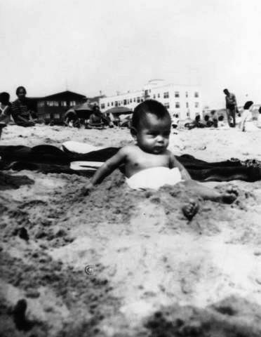
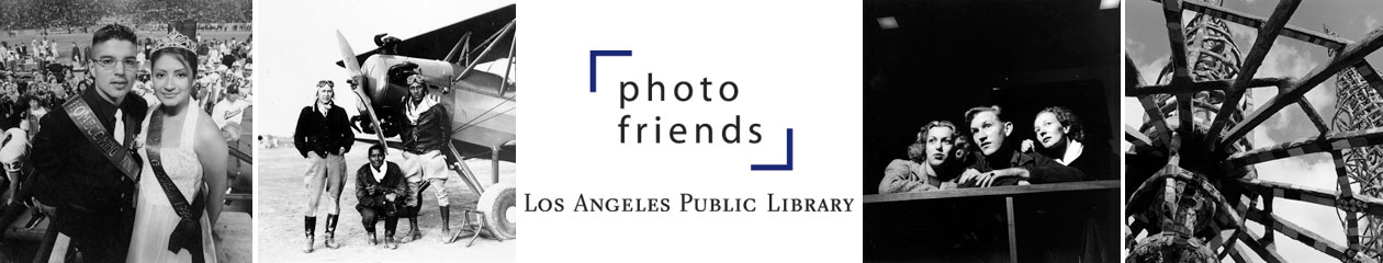
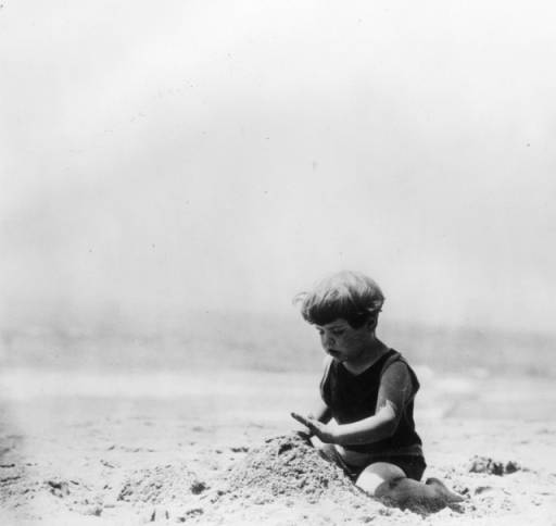
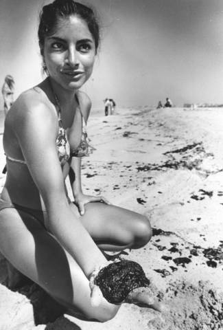
Fredie Martel gets sand between his toes, 1942. Although the photo is labelled Playa Del Rey, it could easily be another beach community. The confines of Playa Del Rey have changed so much over the decades that names tend to get lost in the mix. Photo, Shades of L.A. Collection – Mexican American Community, #00002789.
Water, water, everywhere
Playa Del Rey is a community defined by water. Ballona Creek, once a major river, cuts through the landscape as it courses from the Santa Monica Mountains down to the sea. Two centuries ago, the creek bed also channeled the Los Angeles River before that water course jumped its banks about 1825 due to earthquakes and flooding and began flowing south to San Pedro. Even without the waters of the L.A. River, Ballona Creek was a formidable stream, creating swaths of freshwater wetlands upland and saltwater wetlands as it approached the sea. A wide estuary ballooned into a lagoon surrounded by sand dunes, an ideal spot for recreational boating.
A century ago entrepreneurs dreamed dreams of pleasure pavilions, hotels, car-racing and other attractions. About the turn of the 19th century, an abortive effort was made to dredge out the wetlands and create “Port Ballona” where the railroad would meet shipping lines. Storm and tide foiled this effort and the port of Los Angeles went to San Pedro.
Dreams of a resort town had more success. The first decades of the 20th century saw a hotel and pavilion built on the lagoon with a pier on the oceanfront. Palm trees were trucked in from Santa Monica. Storm gates shielded the lagoon from ocean currents. The Pacific Electric Railway brought day trippers to the shore on its Red Cars. A funicular railroad took the adventurous straight up the bluffs. Housing started going up on the hills and along the shore to the south.
By the 1930s, things started to go sideways. The Great Depression played a part, but there were other factors. Oil was discovered in Venice, just to the north, bringing pollutants and unpleasant smells. At roughly the same time, Ballona Creek was straightened and channelized with concrete, reducing the threat of flooding, but forever changing the character of the wetlands. The lagoon shrank to a fraction of its former size. Two decades later, massive infrastructure projects to the south put the squeeze on the little beach town: the Hyperion Wastewater Treatment Plant, the Scattergood Steam Plant, and, of course, the expansion of Los Angeles International Airport. In the mid-1960s, the airport had hundreds of homes in the Surfridge neighborhood of Playa Del Rey condemned. The runways never extended quite as far as that beachfront community; one can still see ghost sidewalks and streets through a chain-link fence along Vista Del Mar, the coast road. The 1946 construction and 1955 expansion of the Hyperion plant dumped tons of sand and sediment off the coast of Playa Del Rey. While this may have compensated somewhat for beach erosion, it permanently stunted the already sleepy lagoon, cutting it off from all ocean tides.
The most significant change for Playa Del Rey, however, came when the Army Corps of Engineers began work on the project to be known as Marina Del Rey, a huge dredging project that created berths for 5,000 pleasure boats just across the Ballona Creek channel from the heart of Playa Del Rey. In effect, the Marina project, completed in 1965, cut off Playa Del Rey, geographically and ecologically, from its sister beach towns, Venice and Santa Monica, and from the northern lobe of the lagoon. The massive project destroyed 900 acres of wetland; in addition, tons of earth dredged out for the boat channels were deposited off Playa Del Rey. Once again the town became a dumping ground.
In more recent years, residents have had to fight to keep even a small portion of the wetlands that defined the community from falling to development. Beginning in 2002, the Playa Vista development threatened to destroy a good chunk of the remaining freshwater wetlands for upscale housing, businesses, and offices. Negotiation and mitigation have allowed for the preservation and interpretation of some 600 acres of wetlands, now in the care of the California Department of Fish and Wildlife. Plans are afoot to restore the much changed wetlands to some version of their former selves.
Meanwhile, in the lowlands, the little community of Playa Del Rey retains a relatively low profile among beach towns.
Watching change unfold
Photos from the Los Angeles Public Library’s collection show the startling transformation of Playa Del Rey over the past century.-
Del Rey Lagoon (aka “Lake Ballona”) with canoes, about 1902. Photo, Graham Photo Company, Security Pacific National Bank Collection, #00022968.
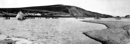
The reconfigured lagoon with a pleasure pavilion (left), ocean pier, and hotel, 1907. Throngs of people along the shore provide the scale. The Hotel Del Rey, pictured center right, burned to the ground in 1924 killing two dozen, including 22 young people. At the time the wooden structure was being used as a home for special needs girls. While stories vary, it appears that the fire was started by one of the teenagers living in the home. Photo, Security Pacific National Bank Collection, #00022975.
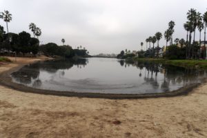
A contemporary photo, taken from roughly the same angle, shows the much reduced size of the lagoon. Photo, Alan Humphrey.
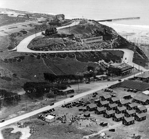
Real estate developers have set up shop at the base of the bluffs along Culver Boulevard, 1925. Dickenson and Gillespie had their headquarters in the large building at middle right, between Pershing Drive and Vista Del Mar Lane. This structure, the Dickenson & Gillespie building, still stands, though much altered, and is the home of Tanner’s Coffee. The small huts in the photo, adjacent to a grandstand, were temporary structures set up to be used by salesmen. The photo appears to be taken during some event, likely the advertised “New Model City Addition” sale held August 2, 1925. During land “booms,” prospective buyers were often lured in to hear a sales pitch with free transportation, food, and other incentives. Dickenson and Gillespie dubbed Playa Del Rey “The Last of the Beaches.” Security Pacific National Bank Collection, #00023000.
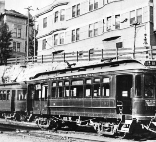
Pacific Electric street cars bound for Playa Del Rey and points south. Photo, Security Pacific National Bank Collection, #00006774.

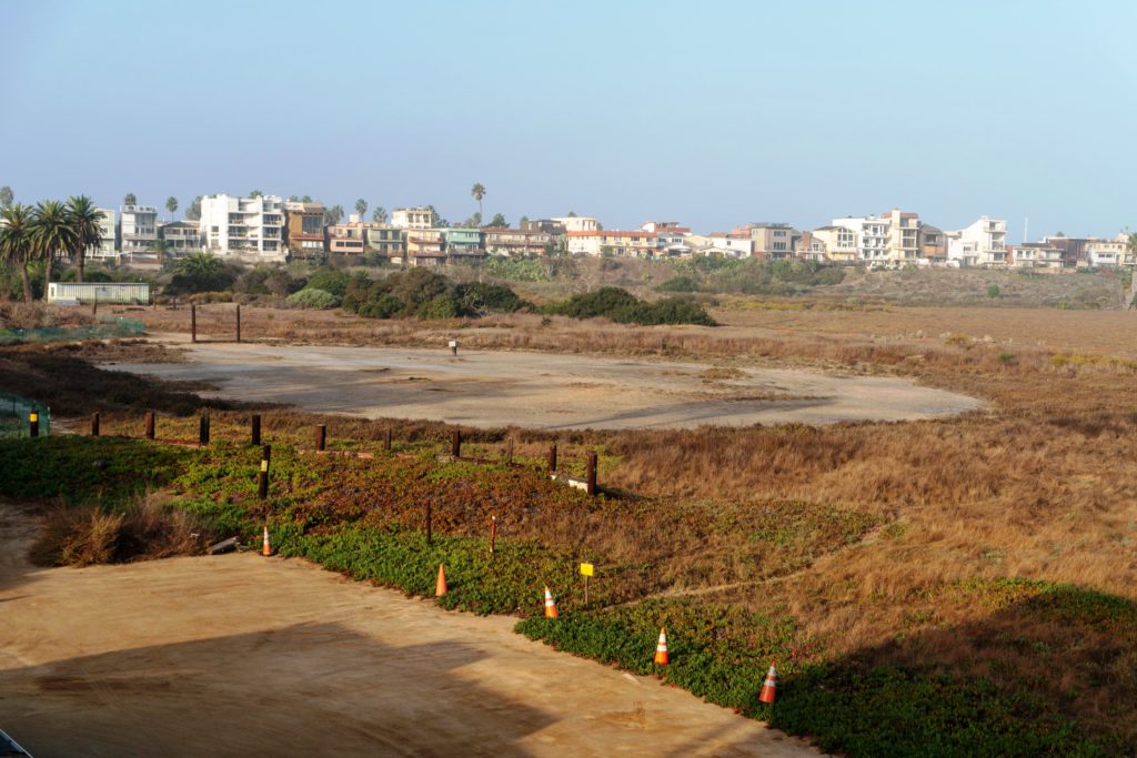
Remnants of the old Pacific Electric street car tracks can be spotted in the Ballona Saltwater Wetlands. A viewing platform atop the piers allows school groups and others to get a close up look at the flora and fauna of the wetlands. The yachts and condos of Marina Del Rey can be seen in the distance.
“All year play ground of happy healthy children: Palisades Del Rey.” So reads the slogan written on this photo dated 1930 in the library’s collection, perhaps a bit of promotional literature. Photo, Security Pacific National Bank Collection, #00070514.
Oil spills and the resulting sludge are common problems on California beaches. Playa Del Rey is no exception. This photo of Ileana Sanchez was taken in 1979. Photo, Toru Kawana, Herald Examiner Collection, #00044224.
Playa Del Ray beach about 1938. A crude rock jetty extends into the sea at left. Photo, Herman J. Schultheis Collection, Los Angeles Photographers Collection, #00022982.
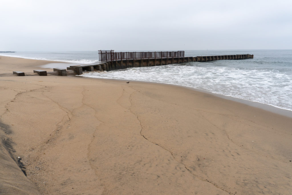
The structure is called the McGurk Beach Jetty, for reasons unknown. It was likely built to protect swimmers from high tides. Photo, Alan Humphrey.
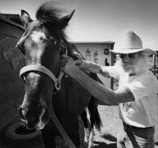
The Playa Del Rey Stables were a fixture in the community from approximately 1910 to 1988. The last days of the riding stables came when the land was optioned for a retirement home that never materialized. Here, one Jim Doggett rubs down his horse, Beau, April 30, 1988. Photo Leo Jarzomb, Herald-Examiner Collection, #00084387.
A circular area of trampled grounds is what’s left of the riding stables. Local lore has it that a young Elizabeth Taylor trained for her role in National Velvet in this corral. Photo, Alan Humphrey.
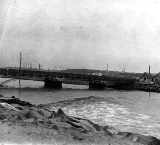
Bridge over Ballona Creek near its outflow, 1941. The photo is taken after the creek has been channelized and before the creation of Marina Del Rey. The channel is swollen due to torrential rains. Photo, Herald Examiner Collection, #00043329. (The photo shows editor’s crop marks.)
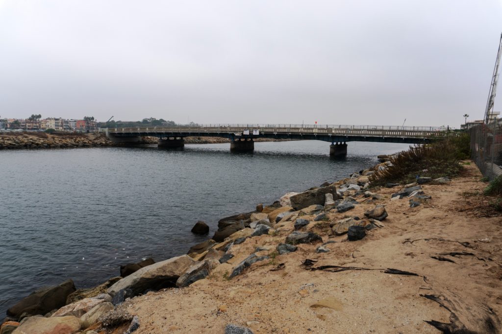
Today’s Ballona Creek Bridge, used by bikes and pedestrians only, links Playa Del Rey to a jetty and bike path. A wide boat channel on the other side of the jetty leads to the eight basins of Marina Del Rey. Photo, Alan Humphrey.